
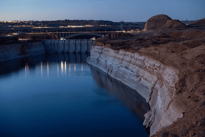
Flash Floods Drive 20-Foot Water Surge at Lake Powell, but Federal Hydrologists Warn Systemic Deficit Persists
By TheNevadaGlobeStaff, November 9, 2026 1:16 pm
PAGE, AZ — An extraordinary deluge across the American Southwest has delivered the largest single autumn water inflow to Lake Powell in over six decades, lifting the drought-stricken reservoir by roughly 20 feet in five weeks.
Telemetry released by the U.S. Bureau of Reclamation (USBR) shows the reservoir’s water surface elevation at the Glen Canyon Dam forebay climbed to 3,537.11 feet above sea level.
The rebound follows a historic low recorded in late September, when the water surface fell to 3,517.24 feet.
The dramatic rise was propelled by an extreme weather pattern that funneled over 20 trillion gallons of rainfall across Nevada, Utah, Arizona, and Colorado.
The resulting flash floods inundated desert washes, broke river-gauge records, and funneled approximately 1.6 million acre-feet of unregulated water directly into the reservoir.
Federal officials noted that this five-week volume represents the highest inflow volume recorded for this time of year since the Glen Canyon Dam began impounding water in 1963.
Despite the historic influx, water resource managers and climate scientists warn that the surge is a temporary reprieve rather than a permanent solution to the Colorado River Basin’s structural supply gap.
+--------------------------------------------------------+
|          LAKE POWELL POST-FLOOD HYDROLOGY DOSSIER      |
+--------------------------------------------------------+
|  - Monitoring Agency: U.S. Bureau of Reclamation (USBR)|
|  - Dam Structure: Glen Canyon Dam (Page, Arizona)      |
|  - Water Surface Elevation: 3,537.11 Feet MSL          |
|  - 30-Day Net Elevation Gain: +18.07 to +20.00 Feet    |
|  - Total Five-Week Inflow: ~1.6 Million Acre-Feet (MAF)|
|  - Historical Benchmark: Largest Autumn Surge Since '63|
|  - Current Active Storage: 6.27 MAF of 24.32 MAF Total |
|  - System Capacity Percentage: 25.8% (Approx. 1/4 Full)|
|  - Buffer Above Minimum Power Pool (3,490 Ft): 47.1 Ft |
|  - Recreational Access: Only 2 of 12 Public Ramps Open |
+--------------------------------------------------------+
Replenishing Storage and Hydropower Buffers
The 20-foot elevation boost provides critical operational breathing room for Glen Canyon Dam’s hydroelectric power generation.
Prior to the storms, Lake Powell was approaching the 3,490-foot minimum power pool threshold, beneath which the dam’s eight turbines risk cavitation damage and complete power disruption to millions of customers across Wyoming, Utah, Colorado, New Mexico, Nevada, and Arizona.
The inflow surge restored Lake Powell’s buffer to 47.11 feet above the minimum power pool.
The lake crossed back into the USBR’s Upper Elevation Balancing Tier (3,525 feet), providing operational flexibility for downstream water deliveries through the Grand Canyon to Lake Mead.
At peak inflow on the Colorado and San Juan rivers, gauging stations recorded water cascading into the lake at rates exceeding 63,000 cubic feet per second (cfs)—a volume typically seen only during peak springtime alpine snowmelt.
Recreational Status and Long-Term Drought Realities
While shorelines advanced across northern Arizona and southern Utah, the National Park Service (NPS) reported that the reservoir remains functionally depleted.
+--------------------------------------------------------+
|             RESERVOIR ELEVATION THRESHOLDS             |
+--------------------------------------------------------+
|  • Full Pool: 3,700.00 Ft (162.9 Ft Above Current Level)|
|  • Equalization Tier: 3,575.00 Ft (37.9 Ft Above)      |
|  • Current Forebay Level: 3,537.11 Ft (25.8% Capacity)  |
|  • Min. Hydropower Pool: 3,490.00 Ft (47.1 Ft Below)   |
|  • Dead Pool (Complete Loss): 3,370.00 Ft (167.1 Ft Below)|
+--------------------------------------------------------+
At 3,537.11 feet, Lake Powell holds 6.27 million acre-feet of water—operating at just 25.8% of its total 24.32 million acre-foot capacity.
The lake remains more than 162 feet below full pool (3,700 feet).
Because modern concrete boat ramps were built for historic water levels, only two of the lake’s twelve designated public launch facilities—Wahweap Main and Bullfrog North—are operational for public trailered vessels.
“A single major precipitation event cannot erase twenty-five years of aridification,” regional hydrologists emphasized.
“These floodwaters bought valuable time for regional infrastructure, but balancing long-term allocations among the Upper and Lower Basin states remains the central imperative.”
Source: U.S. Bureau of Reclamation Upper Colorado River Hydromet Telemetry, National Park Service Glen Canyon National Recreation Area Dispatches, USGS Water Resources Data.
© 2026 Nevada Globe. All Rights Reserved.


- Flash Floods Drive 20-Foot Water Surge at Lake Powell, but Federal Hydrologists Warn Systemic Deficit Persists - November 9, 2026
- Jo Koy Announces Big Game Weekend Return to The Colosseum at Caesars Palace - November 9, 2026
- Final Hours for Clark County Voters to Cure Mail Ballot Signatures as 5 PM Deadline Looms - November 9, 2026
RELATED ARTICLES
-
 September 4, 2024
-
-
January 30, 2023


