

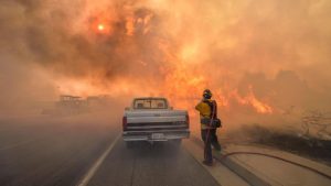
Traffic backup from the Caldor Fire (Photo screenshot: ABC YouTube)
Study: Lake Tahoe Wildfire Evacuation Times May Exceed 14 Hours
Despite TRPA’s official estimation of less than four hours to evacuate fire threatened zones around the basin, the new analyses show evacuation times of 9-14 hours and more
By Dana Tibbitts, August 29, 2024 10:57 am
Yesterday, a first-ever independent Tahoe Basin Wildfire Evacuation Analysis (see below), combining artificial intelligence (AI) and real-life Sierra Nevada wildfire experience, reveals Tahoe workers, residents, and visitors to California and Nevada’s iconic Lake Tahoe could face dangerously long, potentially life-threatening wildfire evacuations.
The release of the Placer and Washoe Tahoe North Shore analyses is part of a larger basin-wide evacuation analysis commissioned by TahoeCleanAir.org, and follows many years of TRPA refusal to conduct required roadway-by-roadway capacity studies (EIR/EIS) to assess impacts of new projects on evacuation capacity for overburdened Lake Tahoe roadways and infrastructure.

“Based on over 400 wildfire evacuation simulations, this first-of-its-kind, publicly transparent analysis aims to raise government land use planning and public awareness of potential evacuation limitations in Tahoe,” says Doug Flaherty, former southern California Fire Combat Battalion Chief and President of TahoeCleanAir.org. “Technology has allowed for more accurate analyses. Many assumptions used community emergency plans are based on subjective and dated information.”
Despite the Tahoe Regional Planning Agency’s (TRPA) official estimation of less than four hours to evacuate fire threatened zones around the basin, the new and far more granular analyses show evacuation times of nine to 14 hours and more, depending on road closures and other variables around the Lake.
“Community members have become frustrated with TRPA and local agencies over the last three years, while realizing that the Tahoe Basin is over capacity,” says Flaherty, who paid $100,000 for the simulation with hopes to recoup his investment through donations to his non-profit
“Yet agencies continue to pursue land, project approvals and policies that bring more and more people into the Tahoe basin, with seemingly little concern to provide a publicly transparent data- driven analysis indicating how long it will take to get them out of the area in case of a wildfire evacuation emergency. From a life safety standpoint, this is dangerous, irresponsible and not sustainable.”
While officials admit that the mostly two-lane roads out of the Tahoe basin would be overwhelmed in the event of an emergency evacuation, the experience of the Caldor fire provided a real-life demonstration of hopelessly inadequate evacuation capacity.
The simulations and an accompanying report are generated by AI technology firms PyroAnalysis and Ladris, in conjunction with veteran firefighters and emergency management experts involved in catastrophic wildfires–including the deadly Camp Fire in 2018, which claimed 85 lives and burned some 14,000 homes in Paradise, CA.
The Tahoe Regional Planning Agency, charged with protecting the renowned Alpine Lake, estimates that around 25 million tourists visit Tahoe annually. Other data indicate 60 million personal day trips annually. However, under the banner of “Destination Stewardship,” TRPA is often seen by residents as prioritizing tourism and recreation over environmental concerns and the well-being of the community.
Three additional geographical Tahoe study areas will soon be available and assess Douglas Tahoe, El Dorado South Shore Tahoe and West Shore Tahoe.
“This is a wake-up call,” says Douglas County resident Ellie Waller. “The health, safety, and quality of life for Lake Tahoe residents, who live, work, and pay taxes here, are consistently neglected in favor of bringing in more tourists, even at the increased risk of wildfire and large-scale evacuations. It is painful to witness the erosion of all we hold dear in this beautiful region. We must hold feet to the fire with these powerful evacuation simulations to push Tahoe’s decision-makers to finally prioritize the health and safety of the Lake, its residents, and, yes, even its visitors over unchecked tourism.”
“At the time (2022) the [evacuation] plan was written it was accurate, but our community has grown and has more visitors.” Washoe County spokesperson Bethany Drysdale said in a statement to the SF Chronicle. “However, each incident is assessed in the moment by trained first responders responsible for making critical life-safety decisions. Those first responders always err on the side of caution and will evacuate accordingly.”
Drydale further stated that Washoe County Emergency Management was updating its regional evacuation plan, but noted that the work was dependent on funding.
“Our funding was cut significantly, which halted our ability to carry out any studies. Nevada County has held an evacuation drill in Incline Village and piloted a website to provide real-time updates, among other wildfire preparations. The county hopes to hire a third party vendor to complete an evacuation study of its most critical areas.”
Final-8-27-24-Indpnt-LT-Wildfire-Evac-Analys-TahoeCleanAir.org_


- Study: Lake Tahoe Wildfire Evacuation Times May Exceed 14 Hours - August 29, 2024
- OPINION: Fighting Fire With Fire: The Demise of Prometheus - August 17, 2024
- OPINION–Under Fire: The Escalating Crises Of USFS Fire Policy In The West - July 12, 2024

Yes, the tourists. Since the plandemic, it has brought in a ton of tourists that prove and show how over loved and over crowded Tahoe has become. The experience now is just a battle. All for the sake of the tourist dollar. So glad i grew up being able to go to the lake since the 60’s, such a shame to see what has happened.
No one stayed home to “save grandma.” They all came to Tahoe…………..
Excellent analysis. The “Camp Fire” in California was made worse by the “rod diet” installed in the area. A straight in and out 4 lane road was replace with a curvy 2 lane road. Also large homes with large out buildings, RVs and trees increase fuel load in “rural areas”.