Carson City Region and Western Nevada to Experience Cooler Temperatures with Chances of Rain and Snow Showers
By TheNevadaGlobeStaff, April 30, 2023 3:00 pm
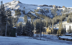
NEVADA – According to the National Weather Service, the Carson City region, western Nevada, and Sierra will experience cooler temperatures this week with chances of valley rain and mountain snow showers. The warm weather will end on Sunday as temperatures decrease with increasing clouds and wind ahead of a low-pressure system moving towards the west coast.
Although area snowmelt will only be slightly affected, the slow-moving low-pressure system will bring periods of mountain snow and valley rain showers throughout the upcoming week. A Flood Watch for the region will continue until 9 a.m. Monday.
The National Weather Service in Reno states that the upper disturbance is projected to bring periods of increased chances for valley showers and upper elevation snow to the Sierra and western Nevada. Although the model guidance shows good general agreement, there is uncertainty regarding the timing and strength of short waves rotating across California and Nevada during the low’s extended stay.
There is a chance for isolated thunderstorms focused mostly over the Basin and Range on Monday into Tuesday, shifting more northwest into the Sierra Front and northeast California thereafter. Projected liquid precipitation amounts through mid-week will range between 0.5 to 1.0 over the Sierra crest with lighter totals of a few hundredths to a couple tenths of an inch across much of western Nevada.
There is a moderate chance for several inches or more of higher elevation snow to fall across the Sierra from around the Lake Tahoe Basin south along the eastern Sierra before the low-pressure system finally exits later next week. Snow levels are projected to range between 5,500 to 6,000 feet overnight Monday into Wednesday morning, meaning there is potential for a couple inches of slushy wet snow around the Lake Tahoe Basin Tuesday morning into Wednesday morning.
Notably, cooler temperatures that will hover near or slightly below normal will persist through the week as the upper low continues to linger over central California.
Credits: Carson Now
Copyright 2022 775 Times, NV Globe. All rights reserved.

RELATED ARTICLES
-
 November 6, 2022
 -
September 29, 2022
-
January 30, 2023