Rain, Thunderstorms, and Hail Hit Western Nevada and Sierra
By TheNevadaGlobeStaff, May 5, 2023 10:08 am
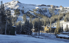
NEVADA – The forecast for Friday shows a strong signal for heavier showers to focus on north-central Nevada, especially for Pershing County north of Lovelock. The weather service also warns that roadway snow accumulation is still possible in heavier bands of snow and during the overnight hours.
Another round of rain and snow showers is expected on Saturday, with the main focus in the Sierra and northeast California. The weather service advises anyone with travel plans through the Sierra to check with CalTrans and/or NDOT for the latest on road conditions.
Breezy southwest to west afternoon winds are expected each day through the weekend, with stronger winds from any thunderstorms that may develop, particularly across the west-central Nevada Basin and Range today.
While high temperatures will remain 5-15 degrees below normal through the weekend, low temperatures in lower elevation valleys should remain above freezing. There is a potential for typically colder valleys to fall near the freezing mark on Saturday night into Sunday morning, with a 10% chance of dipping below freezing. Hard freezes are anticipated for all mountain valleys.
Credits: Carson Now
Copyright 2022 775 Times, NV Globe. All rights reserved.

- National Weather Service Forecasts Persistent Desert Heat Dome as Southern Nevada Temperatures Hover Near 112°F - July 27, 2026
- Vireo Growth Announces Acquisition of Planet 13 Holdings, Unifying Las Vegas Superstore Assets - July 27, 2026
- Sen. Cortez Masto Introduces ‘Fairness for Immigrant Families Act’ to Block Deportations of DACA Recipients - July 27, 2026
RELATED ARTICLES
-
 January 3, 2023
 -
November 6, 2022
-
September 29, 2022