
Dangerous 110-Degree Summer Heat Wave Tracks Into Southern Nevada; Public Cooling Stations Activated
By TheNevadaGlobeStaff, June 22, 2026 3:53 pm
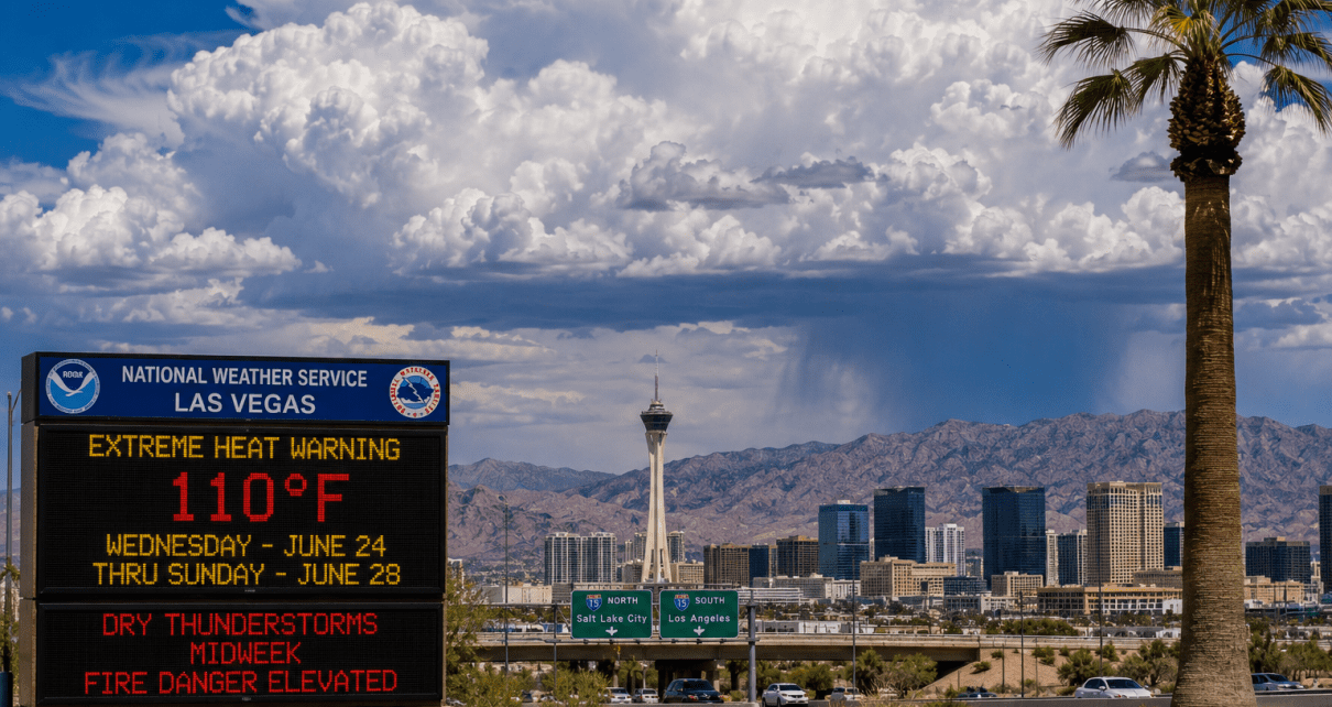
LAS VEGAS, NV — The National Weather Service unsealed a comprehensive regional weather advisory on Monday morning, warning that a dangerous, high-intensity mid-summer heat spike is tracking directly into the low desert floor of the Southern Nevada basin.
The incoming atmospheric thermal loop has prompted immediate joint action from municipal administrators and public safety directors across Clark County to mitigate extreme heat exposure vectors.
The Triple-Digit Threshold and Cooling Matrix
Predictive forecasting models released by NWS meteorologists confirm that high temperatures will climb rapidly across the valley floor, locking in points near 109 to 110 degrees by Wednesday, June 24. The intense thermal conditions are projected to push local heat risks well above traditional seasonal baselines for the late June calendar cycle.
In response to the building public health threat, the Clark County Emergency Management Division, in coordination with the cities of Las Vegas, Henderson, and North Las Vegas, has officially activated the regional public cooling station grid. Beginning immediately and running through June 28, local community centers, municipal pavilions, and public libraries will transition into air-conditioned hydration refuges to safeguard vulnerable demographics and unhoused populations from heat exhaustion loops.
Dry Thunderstorms and Volatile Midweek Fire Threats
Beyond the soaring baseline temperatures, weather tracking systems indicate a secondary, highly volatile atmospheric hazard approaching the region. Monsoon moisture loops creeping steadily north from the lower Mojave Desert are forecast to trigger a series of “dry thunderstorms” across Clark and Lincoln counties midweek.
Meteorologists warn that while these high-based convective developments rarely deliver measurable ground precipitation due to extreme atmospheric evaporation, they are highly efficient at generating sudden, violent dry downburst winds exceeding 40 mph. Coupled with frequent cloud-to-ground lightning strikes, the dry storm cells pose an elevated risk for sudden wildfire ignitions across dry desert brush zones, prompting rural fire protection agencies to place emergency initial-attack crews on absolute standby.
Source: National Weather Service Regional Convective Forecast Matrix, Clark County Emergency Management Public Safety Directive.
© 2026 Nevada Globe. All Rights Reserved.

- Dangerous 110-Degree Summer Heat Wave Tracks Into Southern Nevada; Public Cooling Stations Activated - June 22, 2026
- Multi-Semi Truck Pileup Shuts Down Northbound Interstate 11 Near Boulder City, Freezing Las Vegas Freight Corridor - June 22, 2026
- Workplace Firearm Policies Spark Intense Closed-Door Debates at Las Vegas City Hall Following Yard Slaying - June 22, 2026
RELATED ARTICLES
-
 September 7, 2022
 -
October 25, 2022
-
December 13, 2022